GRASS GIS

GRASS GIS, commonly referred to as GRASS (Geographic Resources Analysis Support System), is a free and open source Geographic Information System (GIS) software suite used for geospatial data management and analysis, image processing, graphics and maps production, spatial modeling, and visualization.

DOI

osgeo project

GRASS GIS

osgeo projectGRASS GIS

The GRASS GIS project is an international team effort with scientists and developers participating from various fields. GRASS – Geographic Resources Analysis Support System has been under continuous development since 1982 and has involved a large number of federal US agencies, universities, and private companies. The core components of GRASS GIS were accomplished by the Construction Engineering Resesarch Laboratory (CERL) in Champaign, Illinois (1982-1995). Since 1997 a worldwide network of developers continues to release new GRASS GIS versions (see GRASS history).

The strength and success of GRASS GIS relies on the user community. With this in mind, the philosophy of the GRASS Development Team is to encourage users to develop their own unique tools and applications for GRASS. Many people have contributed to GRASS GIS in all these years and the project keeps growing. Everybody is invited to join the GRASS GIS development team and improve this powerful suite under terms of GNU General Public License.

Core features

  • Analysis

    • Raster: map algebra, interpolation, mask, solar analysis, landscape structure
    • Vector: network analysis, buffer, overlays, point cloud data
    • Temporal: time series data management and temporal analysis
    • Image processing: aerial and UAV image, satellite data, supervised, unsupervised, and object-based classification
    • Terrain analysis: contour and surface generation, least cost path, slope and aspect analysis
    • Hydrology: flow directions, streams, watersheds (basins), topographic index
    • Point cloud analysis: LiDAR, interpolation, binning, vegetation metrics
    • 3D raster (voxel) analysis: 3D map algebra, 3D interpolation, 3D visualization
    • Spatial statistics: correlation and covariance analysis, regression
    • Geocoding of raster and vector maps
  • Interfaces

    • Graphical user interface (GUI) for new users and interactive analysis
    • Command line interface (CLI) for power users and text-based environments
    • Python scripting library
    • Object-oriented Python API
    • C API
    • Generic XML and WPS description of every module
  • Third-party interfaces

    • QGIS has two different ways to run GRASS GIS modules
    • Web interface through WPS servers
    • R has an interface to GRASS GIS, called rgrass7
    • Ruby also has an interface called grassgis
    • ZOO-Project uses GRASS GIS as back-end for OGC web services
  • Open science ready

    • Publishing algorithms through GRASS GIS
    • Longevity, preservation, and maintenance of the code
    • References to papers listed in the documentation
    • Source code linked from documentation
    • Algorithms created by scientists for scientists
    • Interfaces and APIs addressing needs of different scientists
    • Distribution of binaries for different platforms
    • 30+ years of documented source code

Implemented Standards

  • Geographic JSON (GeoJSON)
  • Georeferenced Tagged Image File Format (GeoTIFF)
  • OpenStreetMap (OSM)
  • Web Map Service (WMS)
  • Web Processing Service (WPS)
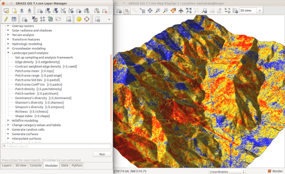
GRASS GIS graphical user interface

GRASS GIS News

View all press releases

Service Providers

Core contributors

View all service providers